A key enabler of many Internet of Things use cases is the ability to track the location and utilization of the physical assets and personnel which are central to business operations. This is a foundational capability for any organization that seeks to gain insights into the efficiency and effectiveness of their business processes.
One of the biggest challenges with tracking asset location and utilization is dealing with blind spots that arise when assets are located across a variety of physical environments. In a typical industrial campus, assets can be indoor, outdoor in wide open spaces, or in outdoor spaces that are covered or obscured. A mix of environments such as this can present a challenge because no single location technology is suited to all environments. Some technologies are efficient outdoors (e.g. Global navigation satellite systems (GNSS)), while others more closely apply to indoor settings (e.g. BLE, UWB, WiFi). Nevertheless, many businesses are looking for solutions that can ensure seamless indoor-outdoor insights in order to operate at maximum efficiency.
This blog aims to cover the three key challenges that must be overcome in order to successfully track and manage assets across both indoor and outdoor settings:
-
Accuracy and Range
-
Network Infrastructure Density
-
Power Consumption
The performance characteristics of the most popular asset tracking approaches can vary greatly across these three aspects of asset tracking. This can make it difficult for businesses to select the best technology mix for their business needs.
1. Accuracy and Range
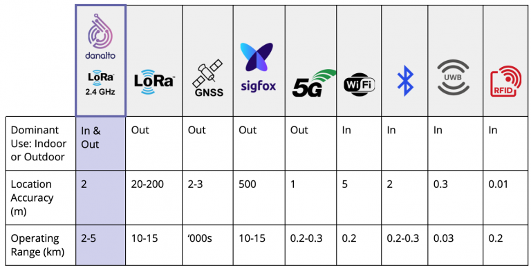
Accuracy and range are two elements which go hand in hand, and their relationship can be a key determinant of whether the technology is suited primarily for indoor or outdoor use. For instance, WiFi, Bluetooth, UWB and RFID have varying accuracies which suit different use cases, but by nature they are short-range technologies which render them best suited to indoor usage. Low Power Wide Area (LPWA) technologies, such as LoRa® and Sigfox, provide coverage over wide areas. Some LPWA technologies offer location services native to the technology, but they cannot match the accuracy of the indoor technologies. For instance, LoRa® location services in the sub-GHz band provide 50m accuracy, whereas indoor tracking technologies typically offer in the range of 10cm. GNSS systems such as GPS provide the best of both worlds in that they are both accurate and long range. However, the requirement for unimpeded views of the sky in order to pick up GNSS signals from satellites means it can only be used in true outdoor environments with little interference from big trees, buildings or coverings of any kind. 5G provides good accuracy but relies on a significant amount of infrastructure which is not yet available, and it also comes with the drawback of requiring operator subscriptions for sim cards.
At danalto we overcome many of these limitations by leveraging a new version of LoRa® that operates at 2.4 GHz globally. This technology is available uniformly on a worldwide basis, operates at higher bandwidth, and is not limited by time on air restrictions which have hampered the relevance of sub-gigahertz LoRa® for asset tracking and positioning. This enables location accuracy from under 5m, ranging up to 5kms.

2. Network Infrastructure Density
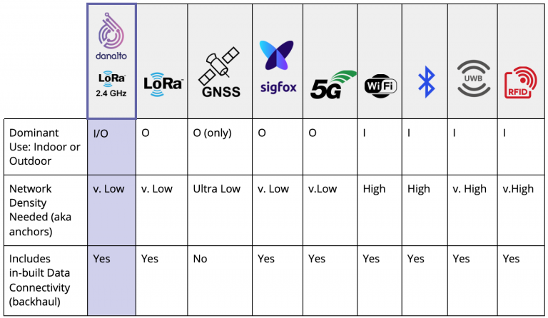
Network infrastructure density refers to the amount of physical infrastructure required in order to provide asset tracking coverage for a given space. Network density is really a function of operational range, and the longer the range is provided by a wireless technology, the lower the density of physical network infrastructure (gateways or anchors) required.
GNSS has the lowest requirement for additional network infrastructure. Tags enabled with this technology work by comparing the time difference on arrival of signals which were sent from different satellites and triangulating these to arrive at a location. One downside is that GNSS does not support data connectivity and thus requires additional network infrastructure for data transit. All other tracking technologies connect to localized anchor points which are typically broadcasting on a radio/cellular network. They use a variety of techniques such as signal strength (RSSI) in the case of WiFi and Bluetooth. Each has its own performance characteristics which also contribute to how densely packed the anchors need to be within a given space.
In the case of LoRa® @ 2.4 GHz, infrastructure density is second only to GNSS because of the higher frequency and wider bandwidth it leverages. This makes it a very interesting technology for outdoor tracking for scenarios where GNSS is for some reason not suitable or too power hungry – for example due to the presence of large buildings or other obstructions.

3. Power Consumption
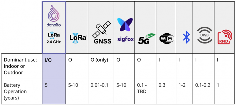
Power requirements of the leading location technologies are worth careful consideration when designing your asset tracking solution. Ideally, tracking devices require zero or low maintenance. However, this only occurs if a tag’s battery life lasts for a sufficient number of months or years. In our experience of helping customers who rely on battery powered tags, 30%-40% of tags are lost, or anchors go offline at a given point because of short battery lifetimes. The replacement or recharging of such devices is time-consuming and expensive.
The Asset Tracking industry understands the importance of helping their customers overcome these challenges around power, and is evolving technology to enhance performance as a result. For instance, LoRa® operating at 2.4GHz can offer 5x longer battery than traditional GNSS, which is 2x longer battery life than Low Power GNSS.

Asset tracking made simple with danalto IoT:
At danalto we are committed to helping our customers overcome the challenges associated with campus-wide asset tracking. As part of this we are incorporating support for leading edge tracking technologies like LoRa® 2.4 GHz and UWB in order to ensure that our customers can seamlessly track and manage their assets both indoor and outdoor – while at the same time minimizing the complexity of providing best of breed positioning intelligence across disparate and incompatible hardware and software stacks.
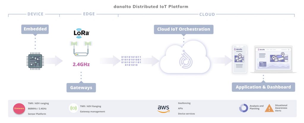
Our platform features a distributed architecture which provides location intelligence firmware for tags and gateway manufacturers and cloud orchestration for implementers of asset tracking solutions.


